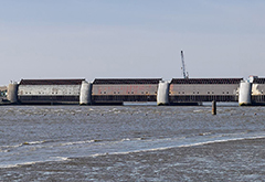
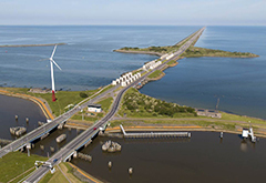
1- Delta Works - Netherlands:

The Delta Works is a series of construction projects in the southwest of the Netherlands to protect a large area of land around the Rhine-Meuse-Scheldt delta from the sea. The works consist of dams, sluices, locks, dykes, levees, and storm surge barriers. The aim of the dams, sluices, and storm surge barriers was to shorten the Dutch coastline, thus reducing the number of dikes that had to be raised. Along with the Zuiderzee Works, Delta Works have been declared one of the Seven Wonders of the Modern World by the American Society of Civil Engineers. More details
2- Thames Flood Barrier - UK:

The Thames Barrier is located downstream of central London, United Kingdom. Operational since 1982, its purpose is to prevent the floodplain of all but the easternmost boroughs of Greater London from being flooded by exceptionally high tides and storm surges moving up from the North Sea. When needed, it is closed (raised) during high tide; at low tide it can be opened to enhance the river's flow towards the sea. Built approximately 3 km (1.9 mi) due east of the Isle of Dogs, its northern bank is in Silvertown in the London Borough of Newham and its southern bank is in the New Charlton area of the Royal Borough of Greenwich. The report of Sir Hermann Bondi on the North Sea flood of 1953 affecting parts of the Thames Estuary and parts of London was instrumental in the building of the barrier. More details
3- IHNC Lake Borgne Surge Barrier - US:


The Inner Harbor Navigation Canal Lake Borgne Surge Barrier is a storm surge barrier constructed near the confluence of and across the Gulf Intracoastal Waterway (GIWW) and the Mississippi River Gulf Outlet (MRGO) near New Orleans. The barrier runs generally north-south from a point just east of Michoud Canal on the north bank of the GIWW and just south of the existing Bayou Bienvenue flood control structure. Navigation gates where the barrier crosses the GIWW and Bayou Bienvenue reduce the risk of storm surge coming from Lake Borgne and/or the Gulf of Mexico. Another navigation gate (Seabrook Floodgate) has been constructed in the Seabrook vicinity where the IHNC meets Lake Pontchartrain to block a storm surge from entering the IHNC from the lake. More details
4. Eider Barrage - Germany:
The Eider Barrage is located at the mouth of the river Eider near Tönning on Germany’s North Sea coast. Its main purpose is protection from storm surges by the North Seas. It is Germany’s largest coastal protection structure. It was also intended to contribute to economic recovery in the districts of Norderdithmarschen and Eiderstedt. Celebrated as a structure of the century, it was opened on 20 March 1973. Following the North Sea flood of 1962 which swept through Tönning, consideration was given to raising the dykes along the banks of the Eider or building a storm surge barrier at its mouth. The latter was chosen and construction work began in 1967. More details
The Saint Petersburg Flood Prevention Facility Complex (unofficially the Saint Petersburg Dam), is a 25 km (16 mi) complex of dams for flood control near Saint Petersburg, Russia. The dam extends from Lomonosov northward to Kotlin Island (and the city of Kronstadt), then turns east toward Cape Lisiy Nos near Sestroretsk. The complex is intended to protect Saint Petersburg from storm surges by separating the Neva Bay from the rest of the Gulf of Finland. Historically, the storm surges from the gulf had caused over 300 floods in the city, several of which had a massive devastating effect. The dam has the capability to protect the city from water rising up to 5 m (16 ft). More details
6. The Hurricane Barrier - US:
Beginning in 1958, the New Bedford Harbor Hurricane Barrier was built from a point about one hundred metres north of Fort Phoenix, in Fairhaven, to Gifford Street on the New Bedford coast. The 20-foot high barrier continues onto land, where three large doors allow street traffic to pass through during calm seas. The longer segment continues along the New Bedford coast to just before Frederick Street. A discontiguous segment protects the top of Clark's Cove in New Bedford, roughly to the Dartmouth border. The barrier consists of an arc of riprap and fill, approximately three kilometres long, surmounted by a service road. More details
7. The MOSE Project - Italy:
MOSE is a project intended to protect the city of Venice, Italy, and the Venetian Lagoon from flooding. The project is an integrated system consisting of rows of mobile gates installed at the Lido, Malamocco and Chioggia inlets that are able to temporarily isolate the Venetian Lagoon from the Adriatic Sea during high tides. Together with other measures such as coastal reinforcement, the raising of quaysides, and the paving and improvement of the lagoon, MOSE is designed to protect Venice and the lagoon from tides of up to 3 metres (9.8 ft). More details
8. Levees:
A levee is an elongated naturally occurring ridge or artificially constructed fill or wall, which regulates water levels. It is usually earthen and often parallel to the course of a river in its floodplain or along low-lying coastlines. The main purpose of artificial levees is to prevent flooding of the adjoining countryside and to slow natural course changes in a waterway to provide reliable shipping lanes for maritime commerce over time; they also confine the flow of the river, resulting in higher and faster water flow. Levees can be mainly found along the sea, where dunes are not strong enough, along rivers for protection against high-floods, along lakes or along polders. Furthermore, levees have been built for the purpose of empoldering, or as a boundary for an inundation area. More details
The Afsluitdijk is a major causeway in the Netherlands, constructed between 1927 and 1932 and running from Den Oever on Wieringen in North Holland province, to the village of Zurich in Friesland province, over a length of 32 kilometres (20 mi) and a width of 90 metres (300 ft), at an initial height of 7.25 metres (23.8 ft) above sea level. It is a fundamental part of the larger Zuiderzee Works, damming off the Zuiderzee, a salt water inlet of the North Sea, and turning it into the fresh water lake of the IJsselmeer. The Afsluitdijk was the initial demonstration site for a 130 km/h (81 mph) speed limit in the Netherlands. More details
10. Barking Creek:
Barking Creek joins the River Roding to the River Thames. It is fully tidal up to the Barking Barrage, which impounds a minimum water level through Barking. In the 1850s, the creek was home to England's largest fishing fleet and a Victorian icehouse – where the fish were landed and stored prior to being transferred to London's fish markets. Barking Creek contains a small number of house boats, and the former village of Creekmouth is nearby. The Barking Creek Barrier is a tidal flood barrier was constructed in the 1980s as part of the Thames flood defence system, opening in 1983. Like all of the subsidiary gates, it is normally closed before, and opened after, the main Thames Barrier. More details


